

The Valley of the Kings


About The Valley of the Kings
About
On the West Bank of the Nile across from modern Luxor, cut into the Theban Hills, lies the Valley of the Kings (KV). Chosen as the burial-place for most of Egypt’s New Kingdom rulers, it was selected for several reasons. It lies only a kilometer or so west of the temples and villages of the Theban people, it is a small valley surrounded by steep cliffs and is easily guarded, the bedrock in which it was cut by torrential rains millions of years ago is limestone of generally good quality, and towering above it is a mountain known today as the Qurn (meaning “the horn” in Arabic). The shape of the Qurn may have reminded the Egyptians of a pyramid, a shape associated with the sun god, Re, and long associated with royal burials.
There are 64* numbered royal and private tombs in KV, ranging from small, pit tombs (KV 54) to huge labyrinths with over 120 corridors and chambers (KV 5). A few tombs have been “discovered” only in the past hundred years or so (KV 62: Tutankhamen; KV 46: Yuya and Thuya; KV 36: Maiherperi; KV 5: Sons of Rameses II ), but most had been opened - and plundered - long ago, some in antiquity, shortly after they were first sealed, others in Graeco-Roman and Byzantine (Coptic) times. There also may still be more. Dr. Zahi Hawass and an Egyptian-led expedition recently made a discovery tentatively numbered KV 65 in the West Valley, and their work is ongoing.
On this note, it is worth highlighting that there are effectively two Valleys of the Kings, the East and the West. The East Valley is the well-known one to which tourists flock and that contains the most tombs. The West Valley covers a much larger area and is the least explored. It has only two royal tombs, KV 22: Amenhotep III, and KV 23: Ay.
*KV 64 will be added to the website in future updates
Noteworthy features:
This is the principal burial site for the rulers of Egypt's New Kingdom. Its tombs contain unique examples of funerary decoration.
Site History
The earliest references we have to modern European visitors in the Valley of the Kings date to the eighteenth century. Early maps, such as that drawn by the scholars who accompanied Napoleon Bonaparte's 1799 expedition to Egypt, or those of Giovanni Belzoni (1818) and John Gardner Wilkinson a decade later, indicate that about twenty-five tombs were accessible since ancient times. Wilkinson was able to see twenty-one tombs and he numbered them in geographic order from the entrance of the Valley southward, then toward the east. Since then, tombs have been numbered in the order of their discovery, KV 64, an unnamed tomb containing the burial of a Chantress (singer) of Amun, being the most recent.
Many people have dug in the Valley of the Kings. One of the first was Giovanni Belzoni, who in 1816-17 discovered eight tombs, the most spectacular being KV 17, the tomb of Sety I. In the late nineteenth century, Victor Loret uncovered sixteen tombs, including a cache of royal mummies in KV 35, the tomb of Amenhetep II. From 1902 on, Theodore M. Davis sponsored thirteen seasons of work during which thirty-five tombs were cleared or discovered. One of his excavators was Howard Carter. In 1907, Carter began working with Earl Carnarvon. In 1922, their work led to the discovery of Tutankhamen's intact burial (KV 62), the only virtually intact royal tomb ever found in the Valley.
Apart from projects engaged in copying specific texts or documenting particular tombs, such as the work of Alexander Piankoff in the tomb of Rameses VI, published in 1954, the Polish epigraphic project in the tomb of Rameses III (KV 11) between 1959 and 1981, the work of Hartvig Altenmüller (KV 14) and Eric Hornung (KV 17, KV 22 and KV 35) there was relatively little archaeological activity in the Valley from 1922 (when the tomb of Tutankhamen was discovered) until the 1970s. Since the 1970s there was a resurgence of activity. In 1972, a project of the University of Minnesota, directed by Otto Schaden, began work in the West Valley in the tomb of Ay (KV 23).
The Theban Mapping Project, under the direction of Kent Weeks, has worked in the Valley of the Kings since 1980. Its publications include the Atlas of the Valley of the Kings, the Valley of the King: a Site Management Handbook in English and Arabic, and reports on the clearing of KV5, the tomb of the sons of Rameses II. A project led by John Romer for the Brooklyn Museum (1978-80) worked in the last royal tomb constructed in the Valley, that of Rameses XI (KV 4). Following documentation in the tomb of Tausert (KV 14) from 1983-1987, Hartwig Altenmüller of the University of Hamburg started excavating the tomb of Bay (KV 13), completing this task in 1994. In 1989, Donald Ryan of Pacific Lutheran University began a re-excavation and recording of several un-inscribed tombs, including KV 21, 27, 28, 44, 45, 48, 49, 50, 51, 52, and 60. KV 39, thought by some to be the burial place of Amenhetep I, was excavated by John Rose beginning in 1989. In 1992 and 1993, Lyla Pinch Brock re-examined and carried out conservation in KV 55.
Nicholas Reeves and Geoffrey Martin examined the area between the tombs of Horemheb (KV 57) and Rameses VI (KV 9). The late Edwin Brock studied royal sarcophagi with particular emphasis on the remains in the tombs of Merenptah (KV 8) and Rameses VI (KV 9), where he reconstructed the inner Sarcophagus. Richard Wilkinson and Kent Weeks edited the Oxford Handbook of the Valley of the Kings (2016) which contains over 30 essays on the development, decoration, symbolism, and history of the KV tombs. An expedition from Waseda University, Tokyo, under the direction of Jiro Kondo cleared, documented, and conserved the tomb of Amenhetep III in the West Valley (KV 22), and the area around it. Zahi Hawass has been clearing areas in both the East and West Valleys of the Kings. A Finnish-Swiss project has cleared and mapped the Village de Repos, a collection of workmen’s huts on the slopes of the Qurn.
There are several archaeological projects currently at work in the Valley of the Kings. Christian Leblanc is clearing and recording the tomb of Rameses II (KV 7) for the CNRS (National Scientific Research Center in France), while across the road, the Theban Mapping Project (TMP) is excavating, recording, and conserving KV 5 (the sons of Rameses II). The tomb of Amenmeses (KV 10) was excavated by the late Otto Schaden, who also discovered KV 63. This work continues under the direction of Salima Ikram. The Ramesses III (KV 11) Publication and Conservation Project, headed by Dr. Anke Weber, has been excavating, documenting, and conserving the tomb of Rameses III (KV 11). Elina Paulin-Grothe and Susanne Bickel direct a project of the Ägyptologische Seminar der Universität Basel, clearing and documenting tomb KV 31, and in the tombs of Rameses X (KV 18), Siptah (KV 47), and Tia’a (KV32), and the surrounding areas. Andreas Dorn has made a thorough study of the Workmen’s Hunts in the East Valley.
Dating
This site was used during the following period(s):
Conservation
Conservation History
Much of the conservation measures enacted in the Valley of the Kings have consisted of removing earlier structures originally designed for touristic activities. This includes the removal of an old restaurant and bathroom from the center of the Valley, relocating souvenir kiosks from inside the Valley, and the demolishing of guard huts and donkey shelters built over and in the vicinity of tombs.
Other Steps have been taken to mitigate the negative affects of the visits of tourists. Cement steps and ramps ways created along paths, bordered by rubble retaining walls, to control the flow of tourists. An air circulation system was installed in KV 62 and plexiglass panels now protect the relief in many tombs from the hands of visitors. The Theban Mapping Project installed new informational signage to give tourists information about the tombs they visit before they enter.
Flash flooding is a serious threat to the tombs and their decoration and has prompted the construction of shelters over entrances of tombs endangered by flood cascades (such as KV 13, KV 14 , KV 15, and KV 35). Flood deflection walls built around tomb entrances also protect from the effects of torrential rains.
Site Condition
Not all of the tombs in the Valley have been fully excavated. Accessible tombs are subject to physical stress from large numbers of visitors. Site maintenance is in need of revision. Trash collection is a problem. Open tombs are in danger of flooding. Internal rock movement is a danger to the structural stability of the tombs.
Hieroglyphs
Valley of the Kings
 The Great Place
tA st aAt

Path leading to KV 20, KV 19, KV 43 and KV 18, entrance.

Asphalt road leading from entrance of Valley of the Kings.
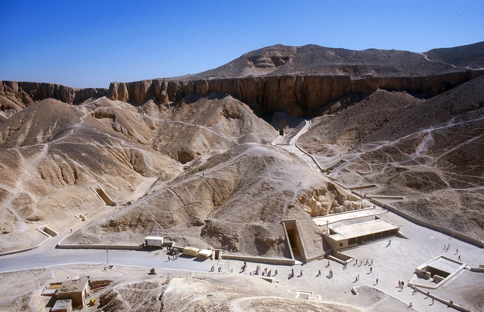
Main valley looking southeast from west cliff above KV 7, showing central hill into which KV 5., KV 6 and KV 55 were cut (left to right). Entrances to KV 3, KV 46 and KV 4 (bottom to top) are in side wadi to left of center, with entrance to KV 19 above.

Cracks in hillside above KV 5.

Filling cracks in hillside above KV 5.

West Valley of the Kings seen from Thoth Hill.

Tomb entrances and inspector's office.

Valley of the Kings with pyramid-shaped Qurn above.

Walton Chan surveying from hilltop above KV 3.

Modern walled courtyard in front of tomb.

Southeast ravine of Valley of the Kings.

Entrance to the Valley of the Kings with vendors' kiosks.

Valley of the Kings.

Dirt track leading to the Valley of the Kings ca. 1910.

Entrance to the Valley of the Kings ca. 1910.

Entrances to KV 6 and KV 55 ca. 1910.

Excavations of Theodore M. Davis, 1909-1910.

Excavations of Theodore M. Davis 1909-1910

Road leading down from the Valley of the Kings.

Hill above KV 11.

Panorama, view from hill above KV 9;looking toward hill above KV 11.

Aerial view of the "Village de Repos" used by the workmen of the Valley of the Kings.

The Valley of the Kings.

Tomb entrance and surroundings during clearance by University of Basel.

Central area from above KV 6, with entrances to KV 10, KV 11, KV 57, KV 09, KV 62

Map of the Valley of the Kings.

Tomb entrances.

Tomb entrances and tourist shelter.

Valley of the Kings, cliff above KV 07, looking south; entrances to KV 62, KV 10, KV 09, KV 11, KV 08.

Valley of the Kings, cliff above KV 8, looking east; entrances to KV 03, KV 46, KV 04, KV 05, KV 06, KV 55, KV 62, KV 19, KV 18, KV 17, KV 16, KV 10, KV 11 and tourist shelter.

Tomb entrances and tourist shelter in the central part of the Valley of the Kings.

Tomb entrances.

Chert layer in geological strata near KV 1.

Reinhard and Eileen Huber, whose firm produced the new information signs in the Valley of the Kings, along with Theban Mapping Project architect Lamice Gabr in front of a new sign.

Roadway into the West Valley of the Kings viewed from the cliffs west of KV 22.

Cliff top between West and East Valley of the Kings north of KV 1.

Valley of the Kings, panorama, looking southeast from cliffs above KV 07, with entrances to KV 62, KV 09, KV 10, KV 11, and KV 08.

Valley of the kings, panorama, looking east from cliff above KV 07, showing entrances to KV 06, KV 07, KV 55, KV 18, KV 17, KV 16, KV 62, KV 10, KV 09, KV 11 and tourist shelter.

Valley of the Kings, panoramic viewfrom cliffs above KV 09, looking southeast.Visible are entrances to KV 03, KV 07, KV 04, KV 05, KV 06, KV 55, KV 62, KV 18, KV 17, KV 16, KV 10, KV 11, KV 57, and toursit shelter.

Hillside eroded by floods.

Tour guide lecturing in front of new information sign installed by the Theban Mapping Project.

Map of the Valley of the Kings.

Tomb entrances, antiquities office and tourist shelter.

Parking lot and cafeteria.

Tombs constructed in the East Valley of the Kings during the first half of Dynasty 18.

Tombs constructed in the East Valley of the Kings from the post-Amarna period to the reign of Sety I.

Tombs constructed during Dynasty 19.

Tombs constructed during Dynasty 20.

Cutting-edge computer equipment used during the early days of the Berkeley Theban Mapping Project.

Valley of the Kings, map

Theban Mapping Project control points on map of the Valley of the Kings.

Approach to a tomb.

Tomb entrances.

John Ross photographing the Valley.

Path between KV 47 and KV 11.

Old rest house, KV 18, KV 17, KV 16, KV 55, KV 62, KV 9, KV 10 and KV 11.

Entrances to KV 20, KV 19 and KV 43.

Chief surveyor David Goodman surveying with a Total Station.

Western Geophysical Corporation testing ground penetrating radar.

Tomb entrances and tourist shelter.

Tomb entrances.

Map of the Valley of the Kings as known to Belzoni.

TMP survey team working in the Valley of the Kings.

Earlier map of the Valley of the Kings.

Valley of the Kings road flooded on 28 May 1995. Courtesy of Richard Sellicks.

View of the tombs of Tutankhamen (KV 62) and Rameses V and VI (KV 09). Courtesy of Richard Sellicks.

Burial chamber D, left wall, lower part, recess. The winged deity Nut. Courtesy of Richard Sellicks.




Articles

Decorating the Tombs

Funerary Compositions
Bibliography
Cabrol, A. Les voies processionnelles de Thèbes. (= Orientalia Lovaniensia Analecta, 97) Paris: Peeters, 2001.
Capart, Jean, Alan H. Gardiner and Baouduin van de Walle. New Light on the Ramesside Tomb-Robberies. Journal of Egyptian Archaeology 22 (1936): 169-193.
Carter, Howard. Excavations at Biban El-Moluk. Annales du Service des Antiquités de l’Égypte 4 (1903): 176-177.
Cauville, Sylvie and Mohammed Ibrahim Ali. La Vallée des Rois: Itinéraire du Visiteur. Leuven: Peeters, 2014. Pp. 1-28, 253-264, 419-432.
Cerný, Jaroslav. The Valley of the Kings (= Bibliothéque d’étude, Institut français d’archéologie orientale du Caire, 61). Cairo: IFAO, 1973.
Chudzik, Patryk M. The Tombs of Asasif: Archaeological Exploration in the 2013/2014 Season. Polish Archaeology in the Mediterranean 24 (1: Research) (2015): 239-246.
Clayton, Peter. The Valley of the Kings. Hove: Wayland, 1995.
Coppens, Filip. Late Dynastic, Greco-Roman, and Christian Tombs: Post-New Kingdom Graffiti. In: Richard H. Wilkinson and Kent R. Weeks (eds.). The Oxford Handbook of the Valley of the Kings. Oxford: Oxford University Press, 2016. Pp. 469-480.
Cross, Stephen W. The Hydrology of the Valley of the Kings. Journal of Egyptian Archaeology 94 (2008): 303-310.
